
Thank you for supporting this site ❤️
Make a donation
Make a donation
Colleton County topographic map
Click on the map to display elevation.
Thank you for supporting this site ❤️
Make a donation
Make a donation
About this map
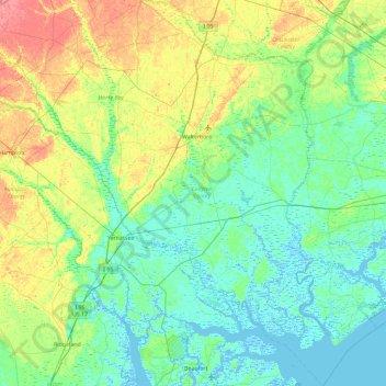
Name: Colleton County topographic map, elevation, terrain.
Location: Colleton County, South Carolina, United States (32.41748 -81.08229 33.18118 -80.24014)
Average elevation: 15 m
Minimum elevation: -4 m
Maximum elevation: 55 m
Thank you for supporting this site ❤️
Make a donation
Make a donation
Other topographic maps
Click on a map to view its topography, its elevation and its terrain.
Palmetto Dunes
United States > South Carolina > Beaufort County > Hilton Head Island
Average elevation: 3 m