
Thank you for supporting this site ❤️
Make a donation
Make a donation
Copenhagen Municipality topographic map
Click on the map to display elevation.
Thank you for supporting this site ❤️
Make a donation
Make a donation
About this map
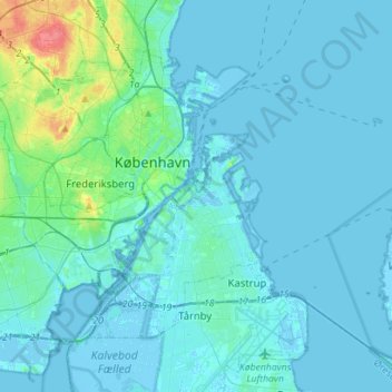
Name: Copenhagen Municipality topographic map, elevation, terrain.
Location: Copenhagen Municipality, Capital Region of Denmark, Denmark (55.61286 12.45300 55.73270 12.73425)
Average elevation: 5 m
Minimum elevation: -6 m
Maximum elevation: 51 m
Thank you for supporting this site ❤️
Make a donation
Make a donation
Other topographic maps
Click on a map to view its topography, its elevation and its terrain.
Thank you for supporting this site ❤️
Make a donation
Make a donation
Thank you for supporting this site ❤️
Make a donation
Make a donation