
Make a donation
Tolland topographic map
Click on the map to display elevation.
Make a donation
Tolland
Tolland's climate is classified as warm summer continental (Dfb), as is typical of the eastern hills of Connecticut. The area enjoys some characteristics hot-summer continental climate (Dfa) due to a relatively high July mean temperature of 70.7 °F (21.5 °C), which is very close to the threshold of 71.6 °F (22 °C) mean temperature required for a hot-summer climate. The area experiences four distinct seasons, with cold, snowy winters and warm to hot summers. The climate of Tolland is distinguished from the warmer climate of nearby Hartford, CT, due to its elevation. The area is prone to blizzards and ice storms in the winter, and during the summer it occasionally experiences tropical activity (though less severe than in lower elevations of the state). Precipitation is distributed fairly evenly throughout the year, with the wettest month being November and the driest being February.
Make a donation
About this map
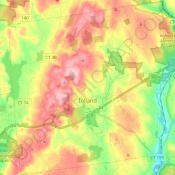
Name: Tolland topographic map, elevation, terrain.
Location: Tolland, Capitol Planning Region, 06084, United States (41.82491 -72.43131 41.92965 -72.29083)
Average elevation: 201 m
Minimum elevation: 94 m
Maximum elevation: 308 m
Make a donation
Other topographic maps
Click on a map to view its topography, its elevation and its terrain.
West Suffield
United States > Connecticut > Capitol Planning Region > Suffield
Average elevation: 59 m
Plantsville
United States > Connecticut > Capitol Planning Region > Southington
Average elevation: 57 m
Four Corners
United States > Connecticut > Capitol Planning Region > Terramuggus
Average elevation: 143 m
Willington Hill
United States > Connecticut > Capitol Planning Region > Willington
Average elevation: 197 m
Make a donation
Griswoldville
United States > Connecticut > Capitol Planning Region > Wethersfield
Average elevation: 34 m
Make a donation
Chaffeeville
United States > Connecticut > Capitol Planning Region > Mansfield
Average elevation: 133 m
West District
United States > Connecticut > Capitol Planning Region > Farmington
Average elevation: 92 m
Talcott Mountain
United States > Connecticut > Capitol Planning Region > Bloomfield
Average elevation: 152 m
Make a donation
South Wethersfield
United States > Connecticut > Capitol Planning Region > Wethersfield > Griswoldville
Average elevation: 22 m
Buckingham
United States > Connecticut > Capitol Planning Region > Glastonbury
Average elevation: 131 m
North Coventry
United States > Connecticut > Capitol Planning Region > Coventry
Average elevation: 195 m
Make a donation
Bishop's Corner
United States > Connecticut > Capitol Planning Region > West Hartford
Average elevation: 47 m
Talcott Mountain
United States > Connecticut > Capitol Planning Region > Bloomfield
Average elevation: 152 m
Johnson Hill
United States > Connecticut > Capitol Planning Region > West Hartford
Average elevation: 34 m
Make a donation
Make a donation
Holcomb Farm
United States > Connecticut > Capitol Planning Region > Granby > West Granby
Average elevation: 116 m
Make a donation
Spoonville
United States > Connecticut > Capitol Planning Region > East Granby
Average elevation: 62 m
Stafford Springs
United States > Connecticut > Capitol Planning Region > Stafford
Average elevation: 200 m
Make a donation
Cottage Grove
United States > Connecticut > Capitol Planning Region > Bloomfield
Average elevation: 31 m
Barbara Drive
United States > Connecticut > Capitol Planning Region > Windsor Locks
Average elevation: 39 m
Make a donation