
Thank you for supporting this site ❤️
Make a donation
Make a donation
Xiahuayuan District topographic map
Click on the map to display elevation.
Thank you for supporting this site ❤️
Make a donation
Make a donation
About this map
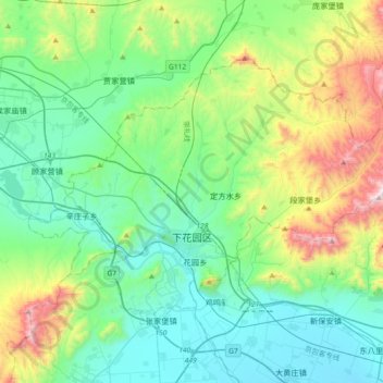
Name: Xiahuayuan District topographic map, elevation, terrain.
Location: Xiahuayuan District, Zhangjiakou, Hebei, 075100, China (40.43696 115.12492 40.63045 115.48936)
Average elevation: 801 m
Minimum elevation: 493 m
Maximum elevation: 1,775 m
Thank you for supporting this site ❤️
Make a donation
Make a donation
Other topographic maps
Click on a map to view its topography, its elevation and its terrain.
Thank you for supporting this site ❤️
Make a donation
Make a donation
Thank you for supporting this site ❤️
Make a donation
Make a donation
Thank you for supporting this site ❤️
Make a donation
Make a donation
Thank you for supporting this site ❤️
Make a donation
Make a donation
Thank you for supporting this site ❤️
Make a donation
Make a donation
Thank you for supporting this site ❤️
Make a donation
Make a donation
Thank you for supporting this site ❤️
Make a donation
Make a donation
Thank you for supporting this site ❤️
Make a donation
Make a donation