
Thank you for supporting this site ❤️
Make a donation
Make a donation
Lancaster County topographic map
Click on the map to display elevation.
Thank you for supporting this site ❤️
Make a donation
Make a donation
About this map
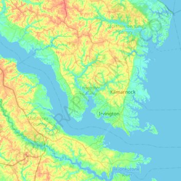
Name: Lancaster County topographic map, elevation, terrain.
Location: Lancaster County, Virginia, United States (37.58508 -76.66818 37.84121 -76.15174)
Average elevation: 13 m
Minimum elevation: -5 m
Maximum elevation: 55 m
Thank you for supporting this site ❤️
Make a donation
Make a donation
Other topographic maps
Click on a map to view its topography, its elevation and its terrain.
Deep Creek
United States > Virginia > Accomack County
It lies at an elevation of 3 feet.
Average elevation: 1 m
Thank you for supporting this site ❤️
Make a donation
Make a donation
Thank you for supporting this site ❤️
Make a donation
Make a donation
Forest Hill Park
United States > Virginia > Williamsburg (city) > Williamsburg > Forest Hill Park
Average elevation: 22 m
Thank you for supporting this site ❤️
Make a donation
Make a donation