
Dintikon topographic map
Interactive map
Click on the map to display elevation.
About this map
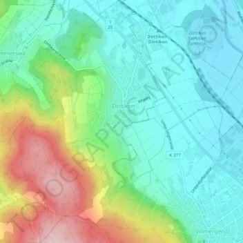
Name: Dintikon topographic map, elevation, terrain.
Location: Dintikon, Bezirk Lenzburg, Aargau, 5606, Schweiz (47.34559 8.20670 47.37749 8.23630)
Average elevation: 489 m
Minimum elevation: 404 m
Maximum elevation: 688 m
Other topographic maps
Click on a map to view its topography, its elevation and its terrain.
Seengen
Schweiz > Aargau > Bezirk Lenzburg
Seengen, Bezirk Lenzburg, Aargau, 5707, Schweiz
Average elevation: 535 m
Brunegg
Schweiz > Aargau > Bezirk Lenzburg
Brunegg, Bezirk Lenzburg, Aargau, 5505, Schweiz
Average elevation: 434 m
Seon
Schweiz > Aargau > Bezirk Lenzburg
Seon, Bezirk Lenzburg, Aargau, 5703, Schweiz
Average elevation: 487 m