
Moroleon topographic map
Interactive map
Click on the map to display elevation.
About this map
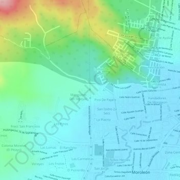
Name: Moroleon topographic map, elevation, terrain.
Location: Moroleon, Moroleón, Guanajuato, 38800, México (20.13410 -101.20821 20.14308 -101.19737)
Average elevation: 1,853 m
Minimum elevation: 1,809 m
Maximum elevation: 1,995 m
Other topographic maps
Click on a map to view its topography, its elevation and its terrain.
Irapuato
México > Guanajuato > Irapuato > Irapuato
Irapuato, Guanajuato, 36500, México
Average elevation: 1,763 m
San Miguel de Allende
México > Guanajuato > San Miguel de Allende
San Miguel de Allende, Guanajuato, México
Average elevation: 1,964 m