
Hamburg topographic map
Interactive map
Click on the map to display elevation.
About this map
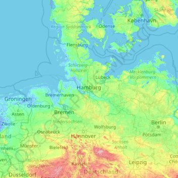
Name: Hamburg topographic map, elevation, terrain.
Location: Hamburg, Duitsland (50.94376 7.40991 56.14376 12.60991)
Average elevation: 56 m
Minimum elevation: -5 m
Maximum elevation: 999 m
Other topographic maps
Click on a map to view its topography, its elevation and its terrain.
Wilhelmsburg
Wilhelmsburg, Hamburg-Mitte, Hamburg, Duitsland
Average elevation: 7 m
Nationalpark Hamburgisches Wattenmeer
Nationalpark Hamburgisches Wattenmeer, Wattwanderweg Neuwerk - Scharhörn, Hamburg Neuwerk, Hamburg-Mitte, Hamburg, 27499, Duitsland
Average elevation: 0 m