
Wehretal topographic map
Interactive map
Click on the map to display elevation.
About this map
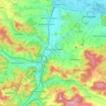
Name: Wehretal topographic map, elevation, terrain.
Location: Wehretal, Werra-Meißner-Kreis, Hessen, 37287, Duitsland (51.11411 9.91173 51.18285 10.08846)
Average elevation: 270 m
Minimum elevation: 154 m
Maximum elevation: 512 m
Other topographic maps
Click on a map to view its topography, its elevation and its terrain.
Witzenhausen
Duitsland > Hessen > Werra-Meißner-Kreis
Witzenhausen, Werra-Meißner-Kreis, Hessen, Duitsland
Average elevation: 297 m
Kalenberg
Duitsland > Hessen > Werra-Meißner-Kreis > Bad Sooden-Allendorf
Kalenberg, Bad Sooden-Allendorf, Werra-Meißner-Kreis, Hessen, 37214, Duitsland
Average elevation: 195 m