
Make a donation
Chattogram District topographic map
Click on the map to display elevation.
Make a donation
Chattogram District
The district's topography is primarily defined by a series of low hill ranges running roughly parallel to the coast and with each other. Between these hill ranges are broad alluvial valleys with sandstone bedrock, and they are also divided by several major rivers, namely the Karnaphuli and Sangu. The most important of these ranges runs roughly from the tripoint with Feni district and Tripura in the north southeast to Chittagong city, known as the Sitakunda hills. This hill range is around 70 kilometres in length and its highest point, Chandranath, is around 350 metres in height. Along the eastern border with Khagrachhari district lies broken hill country. Another set of hills enters the district in the western part of Rangunia Upazila and ends at the Karnaphuli. South of the Karnaphuli, the hills run southeast through the eastern part of Patiya and Chandanaish upazilas to the Sangu River. South of the Sangu lies another hill range close to the coast which divides Banskhali Upazila from Satkania and Lohagara Upazilas, and continues into Cox's Bazar district. The southeastern border with Bandarban district lies along the foothills of the Hill Tracts. To the west of the hill ranges lies a coastal plain with a small width, and along the shore there are numerous beaches which have become tourist destinations.
Make a donation
About this map
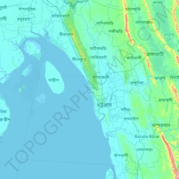
Name: Chattogram District topographic map, elevation, terrain.
Location: Chattogram District, Chattogram Division, Bangladesh (21.85623 91.25964 22.98916 92.21977)
Average elevation: 28 m
Minimum elevation: -2 m
Maximum elevation: 679 m
Make a donation
Other topographic maps
Click on a map to view its topography, its elevation and its terrain.
Rangamati
Bangladesh > Chattogram Division > Rangamati Sadar Upazila
Rangamati (Bengali: রাঙ্গামাটি is the administrative headquarter and town of Rangamati District in the Chittagong Hill Tracts of Bangladesh. The town is located at 22°37'60N 92°12'0E and has an altitude of 14 metres (46 ft). It was the capital of the Chakma kingdom during the British rule…
Average elevation: 68 m
Make a donation
Make a donation