
Thank you for supporting this site ❤️
Make a donation
Make a donation
Semoy topographic map
Click on the map to display elevation.
Thank you for supporting this site ❤️
Make a donation
Make a donation
About this map
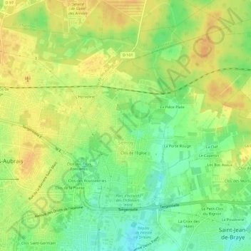
Name: Semoy topographic map, elevation, terrain.
Average elevation: 121 m
Minimum elevation: 102 m
Maximum elevation: 134 m
Thank you for supporting this site ❤️
Make a donation
Make a donation
Other topographic maps
Click on a map to view its topography, its elevation and its terrain.
Les Aubins
Frankrijk > Centre-Val de Loire > Loiret > Saint-Maurice-sur-Aveyron
Average elevation: 182 m
Thank you for supporting this site ❤️
Make a donation
Make a donation
Nailly
Frankrijk > Centre-Val de Loire > Loiret > Dammarie-sur-Loing > Nailly
Average elevation: 150 m