
Bad Oeynhausen topographic map
Interactive map
Click on the map to display elevation.
About this map
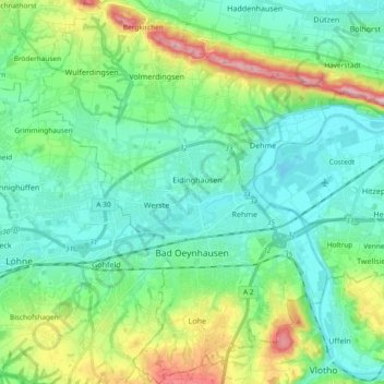
Name: Bad Oeynhausen topographic map, elevation, terrain.
Average elevation: 94 m
Minimum elevation: 38 m
Maximum elevation: 264 m
Other topographic maps
Click on a map to view its topography, its elevation and its terrain.
Struberg
Germany > North Rhine-Westphalia > Kreis Minden-Lübbecke > Hüllhorst
Struberg, Hüllhorst, Kreis Minden-Lübbecke, North Rhine-Westphalia, 32312, Germany
Average elevation: 191 m
Preußisch Oldendorf
Germany > North Rhine-Westphalia > Kreis Minden-Lübbecke
Preußisch Oldendorf, Kreis Minden-Lübbecke, North Rhine-Westphalia, 32361, Germany
Average elevation: 84 m
Börninghausen
Germany > North Rhine-Westphalia > Kreis Minden-Lübbecke > Preußisch Oldendorf
Börninghausen, Preußisch Oldendorf, Kreis Minden-Lübbecke, North Rhine-Westphalia, 32361, Germany
Average elevation: 135 m
Minden
Germany > North Rhine-Westphalia > Kreis Minden-Lübbecke
Minden, Kreis Minden-Lübbecke, North Rhine-Westphalia, Germany
Average elevation: 60 m