
Make a donation
Bozeman topographic map
Click on the map to display elevation.
Make a donation
Bozeman
Bozeman is located at an elevation of 4,820 feet or 1,470 metres. The Bridger Mountains are to the north-northeast, the Tobacco Root Mountains to the west-south-west, the Big Belt Mountains and Horseshoe Hills to the northwest, the Hyalite Peaks of the northern Gallatin Range to the south and the Spanish Peaks of the northern Madison Range to the south-southwest. Bozeman is east of the continental divide, and Interstate 90 passes through the city. It is 84 miles (135 km) east of Butte, 125 miles (201 km) west of Billings, and 93 miles (150 km) north of Yellowstone National Park.
Make a donation
About this map
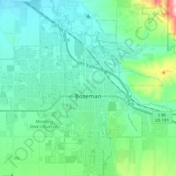
Name: Bozeman topographic map, elevation, terrain.
Location: Bozeman, Gallatin County, Montana, United States (45.63479 -111.11982 45.73326 -110.98424)
Average elevation: 1,495 m
Minimum elevation: 1,392 m
Maximum elevation: 1,974 m
Make a donation
Other topographic maps
Click on a map to view its topography, its elevation and its terrain.
Gallatin Gateway
United States > Montana > Gallatin County
Gallatin Gateway is a census-designated place (CDP) in Gallatin County, Montana, United States. As of the 2020 census, Gallatin Gateway had a population of 967. Elevation is 4,953 ft (1,510 m).
Average elevation: 1,519 m
Make a donation
Make a donation
Bozeman
United States > Montana > Gallatin County > Bozeman
Bozeman is located at an elevation of 4,820 feet (1,470 m). The Bridger Mountains are to the north-northeast, the Tobacco Root Mountains to the west-south-west, the Big Belt Mountains and Horseshoe Hills to the northwest, the Hyalite Peaks of the northern Gallatin Range to the south and the Spanish Peaks of…
Average elevation: 1,679 m