
Alma topographic map
Interactive map
Click on the map to display elevation.
About this map
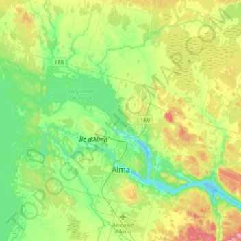
Name: Alma topographic map, elevation, terrain.
Average elevation: 129 m
Minimum elevation: 66 m
Maximum elevation: 261 m
Other topographic maps
Click on a map to view its topography, its elevation and its terrain.
Saint-Nazaire
Canada > Québec > Lac-Saint-Jean-Est
Saint-Nazaire, Lac-Saint-Jean-Est, Saguenay–Lac-Saint-Jean, Québec, G0W 2V0, Canada
Average elevation: 144 m
Saint-Bruno
Canada > Québec > Lac-Saint-Jean-Est
Saint-Bruno, Lac-Saint-Jean-Est, Saguenay–Lac-Saint-Jean, Québec, G0W 2L0, Canada
Average elevation: 151 m
Hébertville
Canada > Québec > Lac-Saint-Jean-Est
Hébertville, Lac-Saint-Jean-Est, Saguenay–Lac-Saint-Jean, Québec, Canada
Average elevation: 257 m
Saint-Gédéon
Canada > Québec > Lac-Saint-Jean-Est
Saint-Gédéon, Lac-Saint-Jean-Est, Saguenay–Lac-Saint-Jean, Québec, G0W 2P0, Canada
Average elevation: 112 m
Métabetchouan–Lac-à-la-Croix
Canada > Québec > Lac-Saint-Jean-Est > Métabetchouan–Lac-à-la-Croix
Métabetchouan–Lac-à-la-Croix, Lac-Saint-Jean-Est, Saguenay–Lac-Saint-Jean, Québec, Canada
Average elevation: 213 m