
Gölsdorf topographic map
Interactive map
Click on the map to display elevation.
About this map
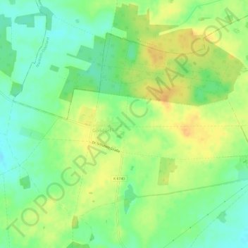
Name: Gölsdorf topographic map, elevation, terrain.
Location: Gölsdorf, Steinhöfel, Oder-Spree, Brandenburg, Deutschland (52.43571 14.07426 52.46273 14.13416)
Average elevation: 79 m
Minimum elevation: 64 m
Maximum elevation: 94 m
Other topographic maps
Click on a map to view its topography, its elevation and its terrain.
Hasenfelde
Deutschland > Brandenburg > Oder-Spree > Steinhöfel
Hasenfelde, Steinhöfel, Oder-Spree, Brandenburg, Deutschland
Average elevation: 63 m