
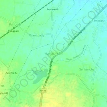
Manikandam topographic map
Interactive map
Click on the map to display elevation.
About this map
Name: Manikandam topographic map, elevation, terrain.
Average elevation: 86 m
Minimum elevation: 77 m
Maximum elevation: 97 m
Other topographic maps
Click on a map to view its topography, its elevation and its terrain.
Kallikudi
India > Tamil Nadu > Srirangam
Kallikudi, Srirangam, Tiruchirappalli District, Tamil Nadu, 620102, India
Average elevation: 83 m
Panjappur
India > Tamil Nadu > Srirangam
Panjappur, Srirangam, Tiruchirappalli District, Tamil Nadu, 620021, India
Average elevation: 81 m
Sattanur
India > Tamil Nadu > Srirangam
Sattanur, Srirangam, Tiruchirappalli District, Tamil Nadu, 620021, India
Average elevation: 85 m
Esanapatty
India > Tamil Nadu > Srirangam
Esanapatty, Srirangam, Tiruchirappalli District, Tamil Nadu, India
Average elevation: 86 m
Perugamani
India > Tamil Nadu > Srirangam > Perugamani
Perugamani, Srirangam, Tiruchirappalli District, Tamil Nadu, 639115, India
Average elevation: 78 m