
Agam topographic map
Interactive map
Click on the map to display elevation.
About this map
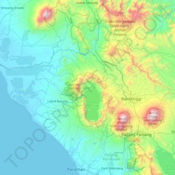
Name: Agam topographic map, elevation, terrain.
Location: Agam, Sumatra occidental, Sumatra, Indonésie (-0.47901 99.74845 -0.03033 100.54375)
Average elevation: 499 m
Minimum elevation: -1 m
Maximum elevation: 2,880 m
Other topographic maps
Click on a map to view its topography, its elevation and its terrain.
Katiet
Indonésie > Sumatra occidental
Katiet, Kepulauan Mentawai, Sumatra occidental, Sumatra, Indonésie
Average elevation: 8 m
Parak Betung
Indonésie > Sumatra occidental > Payakumbuh
Parak Betung, Payakumbuh, Sumatra occidental, Sumatra, 26261, Indonésie
Average elevation: 517 m