
Beja topographic map
Interactive map
Click on the map to display elevation.
About this map
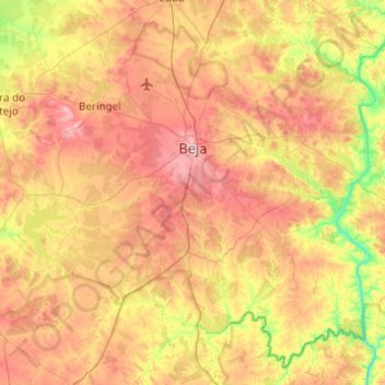
Name: Beja topographic map, elevation, terrain.
Location: Beja, Portugal (37.77646 -8.08315 38.16259 -7.63263)
Average elevation: 157 m
Minimum elevation: 27 m
Maximum elevation: 290 m
Other topographic maps
Click on a map to view its topography, its elevation and its terrain.
Dogueno
Portugal > Beja > Almodôvar > Santa Cruz
Dogueno, Santa Cruz, Almodôvar, Beja, 7700-253, Portugal
Average elevation: 333 m