
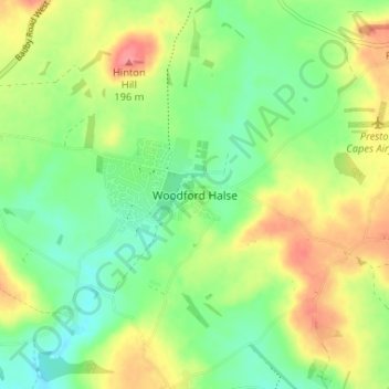
Woodford Halse topographic map
Interactive map
Click on the map to display elevation.
About this map
Name: Woodford Halse topographic map, elevation, terrain.
Average elevation: 154 m
Minimum elevation: 122 m
Maximum elevation: 200 m
Other topographic maps
Click on a map to view its topography, its elevation and its terrain.
Chapel Brampton
United Kingdom > England > West Northamptonshire
Chapel Brampton, West Northamptonshire, England, NN6 8AF, United Kingdom
Average elevation: 91 m
Silverstone
United Kingdom > England > West Northamptonshire
Silverstone, West Northamptonshire, England, United Kingdom
Average elevation: 133 m
Bradden
United Kingdom > England > West Northamptonshire
Bradden, West Northamptonshire, England, United Kingdom
Average elevation: 118 m
Astcote
United Kingdom > England > West Northamptonshire
Astcote, Pattishall, West Northamptonshire, England, NN12 8NR, United Kingdom
Average elevation: 129 m
Pury End
United Kingdom > England > West Northamptonshire > Paulerspury
Pury End, Paulerspury, West Northamptonshire, England, NN12 7NX, United Kingdom
Average elevation: 120 m
West Hunsbury
United Kingdom > England > West Northamptonshire
West Hunsbury, West Northamptonshire, England, United Kingdom
Average elevation: 78 m