
Benòs topographic map
Interactive map
Click on the map to display elevation.
About this map
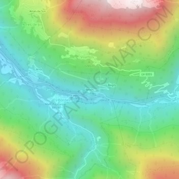
Name: Benòs topographic map, elevation, terrain.
Location: Benòs, es Bòrdes, Val-d'Aran, Lérida, Catalogne, 25551, Espagne (42.71986 0.70848 42.75986 0.74848)
Average elevation: 1,227 m
Minimum elevation: 778 m
Maximum elevation: 2,044 m
Other topographic maps
Click on a map to view its topography, its elevation and its terrain.
Er Espà
Espagne > Catalogne > Val-d'Aran > es Bòrdes
Er Espà, es Bòrdes, Val-d'Aran, Lérida, Catalogne, Espagne
Average elevation: 1,819 m