
Thank you for supporting this site ❤️
Make a donation
Make a donation
Alto topographic map
Click on the map to display elevation.
Thank you for supporting this site ❤️
Make a donation
Make a donation
About this map
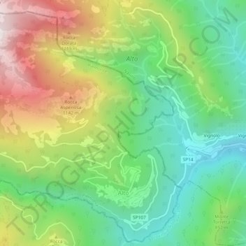
Name: Alto topographic map, elevation, terrain.
Location: Alto, Cuneo, Piedmont, Italy (44.10234 7.96790 44.13443 8.01421)
Average elevation: 776 m
Minimum elevation: 317 m
Maximum elevation: 1,510 m
Thank you for supporting this site ❤️
Make a donation
Make a donation
Other topographic maps
Click on a map to view its topography, its elevation and its terrain.
Colle Fauniera
Italy > Piedmont > Cuneo > Demonte
The Colle Fauniera is a mountain pass in the Cottian Alps, Piedmont, northern Italy, located at 2,480+ m elevation.
Average elevation: 2,315 m
Thank you for supporting this site ❤️
Make a donation
Make a donation
Thank you for supporting this site ❤️
Make a donation
Make a donation
Thank you for supporting this site ❤️
Make a donation
Make a donation
Thank you for supporting this site ❤️
Make a donation
Make a donation
F.ne Scaglione
Italy > Piedmont > Cuneo > Santo Stefano Belbo > F.ne Scaglione
Average elevation: 330 m
Thank you for supporting this site ❤️
Make a donation
Make a donation