
Thank you for supporting this site ❤️
Make a donation
Make a donation
Richmond topographic map
Click on the map to display elevation.
Thank you for supporting this site ❤️
Make a donation
Make a donation
About this map
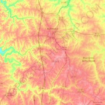
Name: Richmond topographic map, elevation, terrain.
Location: Richmond, Madison County, Kentucky, 40475, United States (37.62352 -84.34202 37.79452 -84.24014)
Average elevation: 281 m
Minimum elevation: 204 m
Maximum elevation: 323 m
Thank you for supporting this site ❤️
Make a donation
Make a donation
Other topographic maps
Click on a map to view its topography, its elevation and its terrain.
Fort Boonesborough State Park
United States > Kentucky > Madison County > Boonesborough
Average elevation: 236 m
Thank you for supporting this site ❤️
Make a donation
Make a donation