
Thank you for supporting this site ❤️
Make a donation
Make a donation
Malekula topographic map
Click on the map to display elevation.
Thank you for supporting this site ❤️
Make a donation
Make a donation
Malekula
Malakula has a maximum elevation of 879 m. Its peak is called Mt. Liambele. In 1768, Louis Antoine de Bougainville gave his name to the straits that separate Malakula from Santo.
Thank you for supporting this site ❤️
Make a donation
Make a donation
About this map
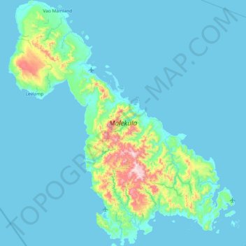
Name: Malekula topographic map, elevation, terrain.
Location: Malekula, Malampa, Vanuatu (-16.58954 167.15358 -15.87878 167.83526)
Average elevation: 69 m
Minimum elevation: 0 m
Maximum elevation: 843 m
Thank you for supporting this site ❤️
Make a donation
Make a donation
Other topographic maps
Click on a map to view its topography, its elevation and its terrain.