
Make a donation
Cimahi topographic map
Click on the map to display elevation.
Make a donation
Cimahi
Cimahi, located 180 km south east of Jakarta, is situated between Bandung and West Bandung Regency. Cimahi comprises three districts (kecamatan), which in turn are sub-divided into fifteen urban villages (kelurahan). Its lowest elevation is 685 metres (2,247 ft) above sea level and directs to Citarum River. Its highest elevation is 1,040 metres (3,410 ft) above sea level, which is part of the slope of mount Tangkuban Perahu and Burangrang. The Cimahi River flows through the city and Cimahi also has two Springs, named Cikuda and Cisontok.
Make a donation
About this map
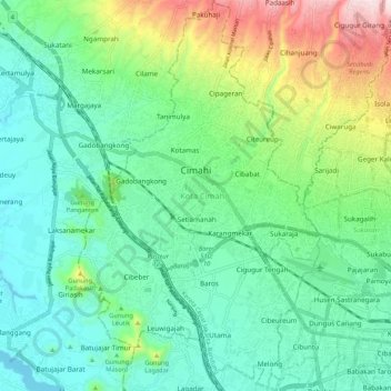
Name: Cimahi topographic map, elevation, terrain.
Location: Cimahi, West Java, Java, Indonesia (-6.93286 107.51032 -6.82735 107.57613)
Average elevation: 779 m
Minimum elevation: 633 m
Maximum elevation: 1,180 m
Make a donation
Other topographic maps
Click on a map to view its topography, its elevation and its terrain.
Make a donation
Make a donation
Make a donation
Make a donation
Make a donation
Bandung
Bandung (Sundanese: ᮘᮔ᮪ᮓᮥᮀ, romanized: Bandung, Sundanese pronunciation: [ˈbandʊŋ]; /ˈbɑːndʊŋ/) is the capital city of the Indonesian province of West Java. It has a population of 2,452,943 within its city limits according to the official estimates as at mid 2021, making it the fourth most…
Average elevation: 893 m
Make a donation
Make a donation
Non Block High Level Conference Monument Park
Indonesia > West Java > Bandung City > Arjuna
Average elevation: 731 m
Make a donation
Make a donation
Make a donation
Bekasi
The City of Bekasi is a part of the Bekasi river basin, located in the downstream area of the basin with slopes ranging from 0 to 2% and elevations between 11 meters to 81 meters above sea level. The city of Bekasi is part of the Bekasi river basin and is located in the downstream area of the basin, with a…
Average elevation: 23 m
Make a donation
Mount Galunggung
Indonesia > West Java > Tasikmalaya > Linggajati
One plane, a British Airways aircraft carrying 240 passengers and traveling from Kuala Lumpur, Malaysia, to Perth, Australia, on 24 June 1982, accidentally entered the ash cloud at night, about 150 km (93 mi; 81 nmi) downwind of the volcano. All four engines failed due to the buildup of volcanic ash, and the…
Average elevation: 1,286 m
Make a donation
lapangan GGM Majalengka
Indonesia > West Java > Majalengka > Majalengka Kulon
Average elevation: 109 m
Make a donation
Make a donation
Pangrango
Indonesia > West Java > Sukabumi
The Mandalawangi peak of the mountain is a tripoint where the borders of Bogor, Cianjur, and Sukabumi Regencies meet. It is the second-highest mountain in West Java after Mount Cereme. Mount Pangrango ranked 26th of the Ribus of Indonesia with a topographic prominence of 2,426 m (7,959 ft). The mountain is…
Average elevation: 2,491 m
Make a donation
Make a donation
Make a donation
Make a donation
Make a donation
Make a donation
Bogor
The city is situated in the western part of Java island, about 53 km south of the capital Jakarta and 85 km northwest of Bandung, the administrative center of West Java Province. Bogor spreads over a basin near volcanoes Salak, which peaks at about 12 km south, and Mount Gede whose top is 22–25 km south-east…
Average elevation: 442 m
Make a donation
Make a donation
Make a donation
Make a donation
Ngamprah
Indonesia > West Java > West Bandung
Ngamprah has an elevation moderated tropical rainforest climate (Af) with moderate rainfall from June to September and heavy rainfall from October to May.
Average elevation: 803 m
Make a donation