
Gemeinde Gaimberg topographic map
Interactive map
Click on the map to display elevation.
About this map
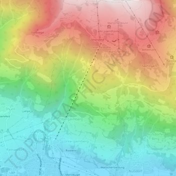
Name: Gemeinde Gaimberg topographic map, elevation, terrain.
Location: Gemeinde Gaimberg, Bezirk Lienz, Tirol, 9905, Oostenrijk (46.83352 12.76033 46.87280 12.80573)
Average elevation: 1,283 m
Minimum elevation: 660 m
Maximum elevation: 2,155 m