
Wattala topographic map
Click on the map to display elevation.
About this map
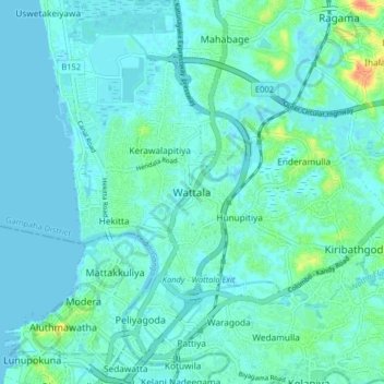
Name: Wattala topographic map, elevation, terrain.
Location: Wattala, Gampaha District, Western Province, 11300, Sri Lanka (6.94987 79.85271 7.02987 79.93271)
Average elevation: 7 m
Minimum elevation: -2 m
Maximum elevation: 46 m
Other topographic maps
Click on a map to view its topography, its elevation and its terrain.
Seethawaka Export Processing Zone
Sri Lanka > Western Province > Avissawella > Seethawaka
Average elevation: 33 m
Uyanwatta Lake
Sri Lanka > Western Province > Bandaragama DS Division > Gelanigama
Average elevation: 16 m
Wevita Lake
Sri Lanka > Western Province > Bandaragama DS Division > Bandaragama
Average elevation: 9 m