
Albulapass topographic map
Interactive map
Click on the map to display elevation.
About this map
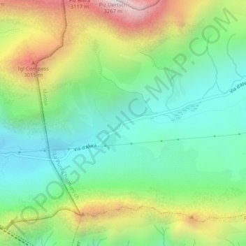
Name: Albulapass topographic map, elevation, terrain.
Location: Albulapass, La Punt Chamues-ch, Maloja, Grisons, 7522, Suisse (46.58255 9.83793 46.58265 9.83803)
Average elevation: 2,560 m
Minimum elevation: 2,202 m
Maximum elevation: 3,228 m
Les trains touristiques Glacier Express et Bernina Express franchissent ce col dans un tunnel à 1 820 mêtres d'altitude et long de 5 865 m.