
Giebelberg topographic map
Interactive map
Click on the map to display elevation.
About this map
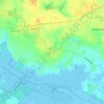
Name: Giebelberg topographic map, elevation, terrain.
Average elevation: 8 m
Minimum elevation: -3 m
Maximum elevation: 25 m
Other topographic maps
Click on a map to view its topography, its elevation and its terrain.
Lütjendorf
Deutschland > Schleswig-Holstein > Ostholstein > Göhl
Lütjendorf, Göhl, Oldenburg-Land, Ostholstein, Schleswig-Holstein, Deutschland
Average elevation: 5 m
Göhl
Deutschland > Schleswig-Holstein > Ostholstein > Göhl
Göhl, Oldenburg-Land, Ostholstein, Schleswig-Holstein, Deutschland
Average elevation: 8 m