
Thank you for supporting this site ❤️
Make a donation
Make a donation
La Severie topographic map
Click on the map to display elevation.
Thank you for supporting this site ❤️
Make a donation
Make a donation
About this map
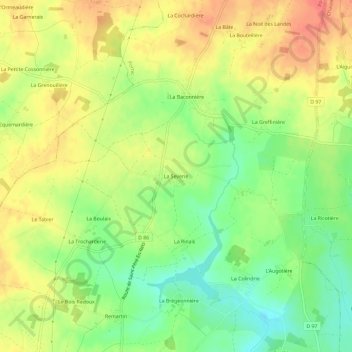
Name: La Severie topographic map, elevation, terrain.
Average elevation: 30 m
Minimum elevation: 1 m
Maximum elevation: 55 m
Thank you for supporting this site ❤️
Make a donation
Make a donation
Other topographic maps
Click on a map to view its topography, its elevation and its terrain.
Plage des Sablons
France > Pays de la Loire > Loire-Atlantique > Pornic > Sainte-Marie-sur-Mer
Average elevation: 14 m