
Thank you for supporting this site ❤️
Make a donation
Make a donation
Montreal topographic map
Click on the map to display elevation.
Thank you for supporting this site ❤️
Make a donation
Make a donation
About this map
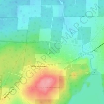
Name: Montreal topographic map, elevation, terrain.
Location: Montreal, Iron County, Wisconsin, United States (46.42057 -90.26314 46.44324 -90.21564)
Average elevation: 464 m
Minimum elevation: 430 m
Maximum elevation: 537 m
Thank you for supporting this site ❤️
Make a donation
Make a donation
Other topographic maps
Click on a map to view its topography, its elevation and its terrain.
Thank you for supporting this site ❤️
Make a donation
Make a donation
Manitowish River
United States > Wisconsin > Iron County > Town of Mercer > Manitowish
Average elevation: 486 m