
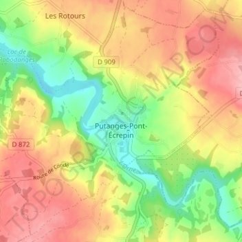
Putanges-Pont-Écrepin topographic map
Interactive map
Click on the map to display elevation.
About this map
Name: Putanges-Pont-Écrepin topographic map, elevation, terrain.
Average elevation: 186 m
Minimum elevation: 119 m
Maximum elevation: 248 m
Cependant, il faut prendre put au sens non pas de « sale », mais plutôt de « mauvais » (signification que sale peut aussi avoir). Deux anciens lieux-dits de Lisieux portent le nom de Putangle (de Puto angulo 1200, Putangle 1267) et Bonangle (Bone Angle 1293, Bon Angle 1326), ce dernier devenu aujourd'hui la rue Bon Ange. Il s'agit de deux coins de l'ancienne île Saint-Dominique sur la Touques, le put angle « mauvais coin » est formé par le coude dangereux ou malcommode de la rivière, et le bon angle « bon coin » s'oppose ainsi à lui. La topographie à Putanges est identique puisqu'il est situé sur une courbe prononcée de l'Orne.
Other topographic maps
Click on a map to view its topography, its elevation and its terrain.
Le Ray
France > Normandie > Orne > Putanges-le-Lac > La Forêt-Auvray
Le Ray, La Forêt-Auvray, Putanges-le-Lac, Argentan, Orne, Normandie, France métropolitaine, 61210, France
Average elevation: 164 m
La Fresnaye-au-Sauvage
France > Normandie > Orne > Putanges-le-Lac
La Fresnaye-au-Sauvage, Putanges-le-Lac, Argentan, Orne, Normandie, France métropolitaine, 61210, France
Average elevation: 214 m
Rabodanges
France > Normandie > Orne > Putanges-le-Lac
Rabodanges, Putanges-le-Lac, Argentan, Orne, Normandie, France métropolitaine, 61210, France
Average elevation: 188 m
Les Courtils
France > Normandie > Orne > Putanges-le-Lac > Putanges-Pont-Écrepin
Les Courtils, Putanges-Pont-Écrepin, Putanges-le-Lac, Argentan, Orne, Normandie, France métropolitaine, 61210, France
Average elevation: 186 m
Les Rotours
France > Normandie > Orne > Putanges-le-Lac
Les Rotours, Putanges-le-Lac, Argentan, Orne, Normandie, France métropolitaine, 61210, France
Average elevation: 191 m
Le Hamel
France > Normandie > Orne > Putanges-le-Lac > La Forêt-Auvray > Le Hamel
Le Hamel, La Forêt-Auvray, Putanges-le-Lac, Argentan, Orne, Normandie, France métropolitaine, 61210, France
Average elevation: 173 m
Le Perrey
France > Normandie > Orne > Putanges-le-Lac > Rabodanges
Le Perrey, Rabodanges, Putanges-le-Lac, Argentan, Orne, Normandie, France métropolitaine, 61210, France
Average elevation: 177 m
Le Chenay
France > Normandie > Orne > Putanges-le-Lac > Putanges-Pont-Écrepin
Le Chenay, Putanges-Pont-Écrepin, Putanges-le-Lac, Argentan, Orne, Normandie, France métropolitaine, 61210, France
Average elevation: 188 m
Saint-Aubert-sur-Orne
France > Normandie > Orne > Putanges-le-Lac
Saint-Aubert-sur-Orne, Putanges-le-Lac, Argentan, Orne, Normandie, France métropolitaine, 61210, France
Average elevation: 200 m
Sainte-Croix-sur-Orne
France > Normandie > Orne > Putanges-le-Lac
Sainte-Croix-sur-Orne, Putanges-le-Lac, Argentan, Orne, Normandie, France métropolitaine, 61210, France
Average elevation: 186 m