
Make a donation
Antioquia topographic map
Click on the map to display elevation.
Make a donation
Antioquia
Due to its geographical isolation (as it is located among mountains), Antioquia suffered supply problems. Its topography did not allow for much agriculture, so the city became dependent upon trade, especially of gold and gin for the colonization of new land. Much of this trade was due to reforms passed after a 1785 visit from Juan Antonio Mon y Velarde, an inspector of the Spanish Crown. The Antioquia became colonizers and traders.
Make a donation
About this map
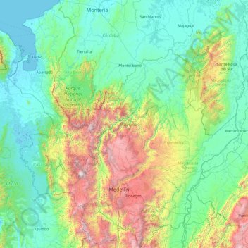
Name: Antioquia topographic map, elevation, terrain.
Location: Antioquia, RAP del Agua y la Montaña, Colombia (5.41863 -77.12709 8.88980 -73.87959)
Average elevation: 614 m
Minimum elevation: -4 m
Maximum elevation: 3,838 m
Make a donation
Other topographic maps
Click on a map to view its topography, its elevation and its terrain.
Tunja
Tunja has a population of 172,548 inhabitants according to the 2018 Census. 0.1% of the city is indigenous, 0.4% is black, and 99.5% is white and Mestizo. It is located in central Colombia, at an elevation ranging from approximately 2,700 metres (8,900 ft) to 2,900 metres (9,500 ft). The city centre is at an…
Average elevation: 2,824 m
Pacho
Pacho is a municipality and town of Colombia in the department of Cundinamarca. Pacho is part of the Rionegro Province and the urban centre is situated at a distance of 88 kilometres (55 mi) from the capital Bogotá at an altitude of 2,136 metres (7,008 ft), while the altitude ranges from 1,000 metres (3,300…
Average elevation: 1,881 m
Make a donation
Make a donation
Make a donation