
Hölstein topographic map
Interactive map
Click on the map to display elevation.
About this map
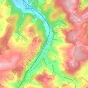
Name: Hölstein topographic map, elevation, terrain.
Location: Hölstein, Bezirk Waldenburg, Basel-Landschaft, 4434, Schweiz (47.40898 7.75760 47.44499 7.79132)
Average elevation: 520 m
Minimum elevation: 384 m
Maximum elevation: 615 m
Other topographic maps
Click on a map to view its topography, its elevation and its terrain.
Oberdorf (BL)
Schweiz > Basel-Landschaft > Bezirk Waldenburg > Oberdorf (BL)
Oberdorf (BL), Bezirk Waldenburg, Basel-Landschaft, 4436, Schweiz
Average elevation: 657 m
Reigoldswil
Schweiz > Basel-Landschaft > Bezirk Waldenburg > Reigoldswil
Reigoldswil, Bezirk Waldenburg, Basel-Landschaft, 4418, Schweiz
Average elevation: 736 m