
Thank you for supporting this site ❤️
Make a donation
Make a donation
Damdama Lake topographic map
Click on the map to display elevation.
Thank you for supporting this site ❤️
Make a donation
Make a donation
About this map
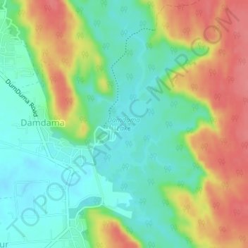
Name: Damdama Lake topographic map, elevation, terrain.
Location: Damdama Lake, Sohna, Gurugram District, Haryana, India (28.29646 77.12706 28.31809 77.13644)
Average elevation: 242 m
Minimum elevation: 211 m
Maximum elevation: 288 m
Thank you for supporting this site ❤️
Make a donation
Make a donation
Other topographic maps
Click on a map to view its topography, its elevation and its terrain.