
Thank you for supporting this site ❤️
Make a donation
Make a donation
Cavalière topographic map
Click on the map to display elevation.
Thank you for supporting this site ❤️
Make a donation
Make a donation
About this map
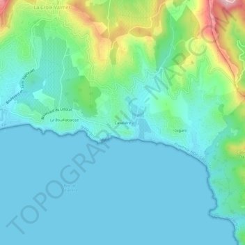
Name: Cavalière topographic map, elevation, terrain.
Average elevation: 47 m
Minimum elevation: 0 m
Maximum elevation: 233 m
Thank you for supporting this site ❤️
Make a donation
Make a donation
Other topographic maps
Click on a map to view its topography, its elevation and its terrain.
Plage du Débarquement
France > Provence-Alpes-Côte d'Azur > Var > La Croix-Valmer > La Bouillabaisse
Average elevation: 22 m