
Schwelm topographic map
Interactive map
Click on the map to display elevation.
About this map
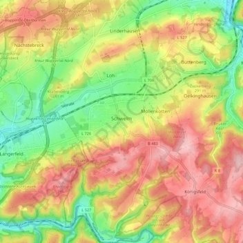
Name: Schwelm topographic map, elevation, terrain.
Average elevation: 264 m
Minimum elevation: 165 m
Maximum elevation: 361 m
Schwelm liegt am nordwestlichen Rand des rechtsrheinischen Schiefergebirges. Auf dem Stadtgebiet schwankt die Höhe zwischen 181 und 352 m ü. NN.
Other topographic maps
Click on a map to view its topography, its elevation and its terrain.
Witten
Deutschland > Nordrhein-Westfalen > Ennepe-Ruhr-Kreis
Witten, Ennepe-Ruhr-Kreis, Nordrhein-Westfalen, Deutschland
Average elevation: 137 m