
Irving topographic map
Interactive map
Click on the map to display elevation.
About this map
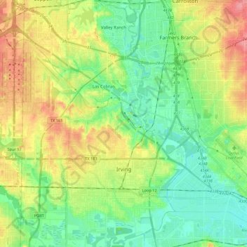
Name: Irving topographic map, elevation, terrain.
Location: Irving, Dallas County, Texas, Vereinigte Staaten von Amerika (32.77179 -97.03404 32.95397 -96.88878)
Average elevation: 149 m
Minimum elevation: 120 m
Maximum elevation: 196 m
Other topographic maps
Click on a map to view its topography, its elevation and its terrain.
Dallas
Vereinigte Staaten von Amerika > Texas > Dallas County
Dallas, Dallas County, Texas, Vereinigte Staaten von Amerika
Average elevation: 160 m
Sachse
Vereinigte Staaten von Amerika > Texas > Dallas County > Sachse > Sachse
Sachse, Dallas County, Texas, 75048, Vereinigte Staaten von Amerika
Average elevation: 158 m