
Thank you for supporting this site ❤️
Make a donation
Make a donation
Kanazi topographic map
Click on the map to display elevation.
Thank you for supporting this site ❤️
Make a donation
Make a donation
About this map
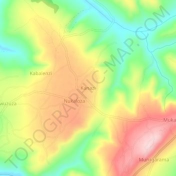
Name: Kanazi topographic map, elevation, terrain.
Location: Kanazi, Ngara, Kagera, Lake Zone, Tanzania (-2.60266 30.48015 -2.56266 30.52015)
Average elevation: 1,534 m
Minimum elevation: 1,411 m
Maximum elevation: 1,662 m
Thank you for supporting this site ❤️
Make a donation
Make a donation
Other topographic maps
Click on a map to view its topography, its elevation and its terrain.