
Thank you for supporting this site ❤️
Make a donation
Make a donation
Bad Schmiedeberg topographic map
Click on the map to display elevation.
Thank you for supporting this site ❤️
Make a donation
Make a donation
About this map
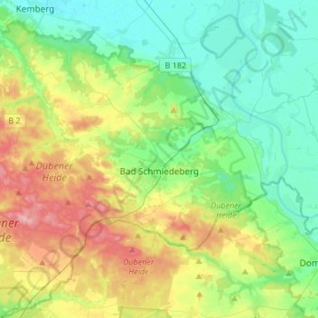
Name: Bad Schmiedeberg topographic map, elevation, terrain.
Location: Bad Schmiedeberg, Wittenberg, Saxony-Anhalt, 06905, Germany (51.61100 12.60763 51.77779 12.84554)
Average elevation: 107 m
Minimum elevation: 66 m
Maximum elevation: 191 m
Thank you for supporting this site ❤️
Make a donation
Make a donation