
Thank you for supporting this site ❤️
Make a donation
Make a donation
Lake Nebagamon topographic map
Click on the map to display elevation.
Thank you for supporting this site ❤️
Make a donation
Make a donation
About this map
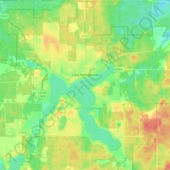
Name: Lake Nebagamon topographic map, elevation, terrain.
Average elevation: 351 m
Minimum elevation: 326 m
Maximum elevation: 381 m
Thank you for supporting this site ❤️
Make a donation
Make a donation
Other topographic maps
Click on a map to view its topography, its elevation and its terrain.
Thank you for supporting this site ❤️
Make a donation
Make a donation
Big Manitou Falls
United States > Wisconsin > Douglas County > Town of Superior
Average elevation: 295 m