
Thank you for supporting this site ❤️
Make a donation
Make a donation
Atiwa West District topographic map
Click on the map to display elevation.
Thank you for supporting this site ❤️
Make a donation
Make a donation
About this map
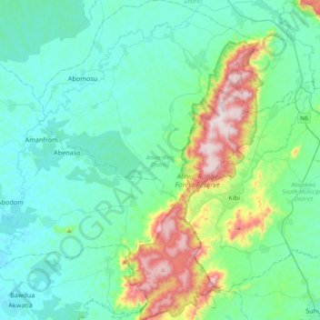
Name: Atiwa West District topographic map, elevation, terrain.
Location: Atiwa West District, Eastern Region, Ghana (6.02512 -0.77755 6.39231 -0.51988)
Average elevation: 265 m
Minimum elevation: 127 m
Maximum elevation: 829 m
Thank you for supporting this site ❤️
Make a donation
Make a donation
Other topographic maps
Click on a map to view its topography, its elevation and its terrain.