
Fishtail topographic map
Interactive map
Click on the map to display elevation.
About this map
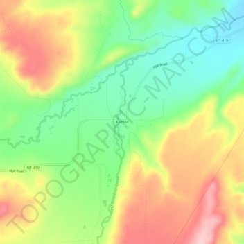
Name: Fishtail topographic map, elevation, terrain.
Location: Fishtail, Stillwater County, Montana, United States (45.43307 -109.52546 45.47307 -109.48546)
Average elevation: 1,395 m
Minimum elevation: 1,309 m
Maximum elevation: 1,498 m
Other topographic maps
Click on a map to view its topography, its elevation and its terrain.
Columbus
United States > Montana > Stillwater County
Columbus, Stillwater County, Montana, United States
Average elevation: 1,107 m
Absarokee
United States > Montana > Stillwater County > Absarokee
Absarokee, Stillwater County, Montana, 59001, United States
Average elevation: 1,274 m