
Make a donation
Souss-Massa topographic map
Click on the map to display elevation.
Make a donation
Souss-Massa
Three factors influence the semi-arid Mediterranean climate of the region: the topography, the oceanic coastline, and the Sahara Desert. In the northern part, dominated by the Atlas Mountains, the climate shifts from humid to semi-arid as one moves towards the plain. This plain, which stretches from the base of the Atlas and includes the basins of the Souss and Massa rivers, experiences an arid climate despite its broad exposure to the Atlantic Ocean. Meanwhile, the southern and southeastern sections of the region, which lie on the northern edge of the Sahara, have a desert climate.
Make a donation
About this map
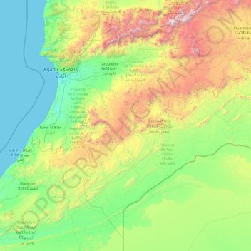
Name: Souss-Massa topographic map, elevation, terrain.
Location: Souss-Massa, Morocco (28.31106 -10.01009 31.16659 -6.35365)
Average elevation: 741 m
Minimum elevation: 0 m
Maximum elevation: 4,023 m
Make a donation
Other topographic maps
Click on a map to view its topography, its elevation and its terrain.