
Make a donation
Ajlun topographic map
Click on the map to display elevation.
Make a donation
Ajlun
Ajloun is known for its high elevation, which makes it one of the coolest cities in Jordan, with an average maximum temperature during January of 8.2 degrees Celsius, and a minimum average temperature of 2.8 degrees Celsius. Snow is common during the winter.
Make a donation
About this map
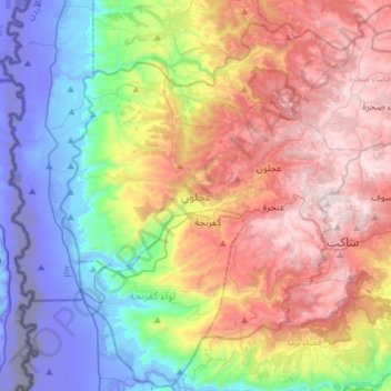
Name: Ajlun topographic map, elevation, terrain.
Location: Ajlun, Jordan (32.18976 35.59209 32.43736 35.89212)
Average elevation: 442 m
Minimum elevation: -346 m
Maximum elevation: 1,246 m
Make a donation
Other topographic maps
Click on a map to view its topography, its elevation and its terrain.
Make a donation
Make a donation
Make a donation
Zarqa
Jordan > Zarqa > Zarqa Sub-District
Zarqa has a cold semi-arid climate (Köppen climate classification: BSk). The average annual temperature is 17.4 °C (63.3 °F), and around 182 mm (7.17 in) of precipitation falls annually, mostly in winter months. Zarqa's elevation is 619 meters above sea level, and the city occasionally receives snowfall in…
Average elevation: 617 m