
Thank you for supporting this site ❤️
Make a donation
Make a donation
Gongala topographic map
Click on the map to display elevation.
Thank you for supporting this site ❤️
Make a donation
Make a donation
Gongala
Gongala is a mountain in the Ratnapura District of Sri Lanka. At a summit elevation of 1,358 m (4,455 ft), it is the 15th tallest mountain in Sri Lanka.
Thank you for supporting this site ❤️
Make a donation
Make a donation
About this map
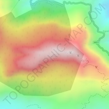
Name: Gongala topographic map, elevation, terrain.
Average elevation: 1,026 m
Minimum elevation: 664 m
Maximum elevation: 1,333 m
Thank you for supporting this site ❤️
Make a donation
Make a donation
Other topographic maps
Click on a map to view its topography, its elevation and its terrain.