
Thank you for supporting this site ❤️
Make a donation
Make a donation
Trasching topographic map
Click on the map to display elevation.
Thank you for supporting this site ❤️
Make a donation
Make a donation
About this map
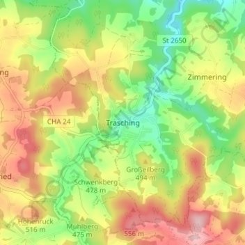
Name: Trasching topographic map, elevation, terrain.
Location: Trasching, Roding, Landkreis Cham, Bayern, Deutschland (49.13559 12.44075 49.17559 12.48075)
Average elevation: 463 m
Minimum elevation: 364 m
Maximum elevation: 574 m
Thank you for supporting this site ❤️
Make a donation
Make a donation
Other topographic maps
Click on a map to view its topography, its elevation and its terrain.
Burgruine Schwärzenburg
Deutschland > Bayern > Landkreis Cham > Roding > Strahlfeld
Die Höhenburg wurde vermutlich im 13. Jahrhundert auf dem Grund des Bamberger Bischofs von den Herren von Fronau (Adelsgeschlecht), die schon Anfang des 12. Jahrhunderts urkundlich genannt wurden, erbaut. Eine Vorgängeranlage der Höhenburg könnte die Turmhügelburg Haselberg auf dem Gebiet des Haselbergs…
Average elevation: 455 m