
Thank you for supporting this site ❤️
Make a donation
Make a donation
Lonand topographic map
Click on the map to display elevation.
Thank you for supporting this site ❤️
Make a donation
Make a donation
Lonand
Lonand is located at 18°02′25″N 74°11′14″E / 18.0404°N 74.1872°E / 18.0404; 74.1872. It has an average elevation of 597 metres (1961 feet). It is situated on the banks of Khemavati river at the border of Pune district and Satara district.
Thank you for supporting this site ❤️
Make a donation
Make a donation
About this map
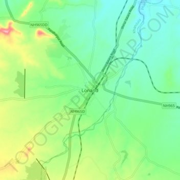
Name: Lonand topographic map, elevation, terrain.
Location: Lonand, Khandala, Satara, Maharashtra, 415521, India (17.99880 74.14693 18.07880 74.22693)
Average elevation: 599 m
Minimum elevation: 553 m
Maximum elevation: 703 m
Thank you for supporting this site ❤️
Make a donation
Make a donation