
Peising topographic map
Interactive map
Click on the map to display elevation.
About this map
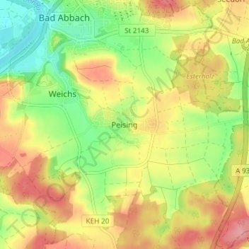
Name: Peising topographic map, elevation, terrain.
Average elevation: 387 m
Minimum elevation: 332 m
Maximum elevation: 441 m
Other topographic maps
Click on a map to view its topography, its elevation and its terrain.
Hochstetten
Deutschland > Bayern > Landkreis Kelheim > Bad Abbach
Hochstetten, Bad Abbach, Landkreis Kelheim, Bayern, 93077, Deutschland
Average elevation: 392 m
Poikam
Deutschland > Bayern > Landkreis Kelheim > Bad Abbach > Poikam
Poikam, Bad Abbach, Landkreis Kelheim, Bayern, 93077, Deutschland
Average elevation: 371 m