
Buxton topographic map
Interactive map
Click on the map to display elevation.
About this map
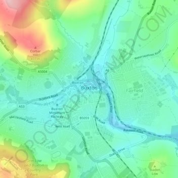
Name: Buxton topographic map, elevation, terrain.
Location: Buxton, High Peak, Derbyshire, Angleterre, Royaume-Uni (53.24499 -1.93022 53.27317 -1.88366)
Average elevation: 334 m
Minimum elevation: 285 m
Maximum elevation: 460 m
Other topographic maps
Click on a map to view its topography, its elevation and its terrain.
Glossop
Royaume-Uni > Angleterre > Derbyshire > High Peak
Glossop, High Peak, Derbyshire, Angleterre, SK13 8BP, Royaume-Uni
Average elevation: 284 m