
Vergötschen topographic map
Interactive map
Click on the map to display elevation.
About this map
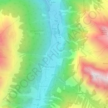
Name: Vergötschen topographic map, elevation, terrain.
Location: Vergötschen, Kaunertal, Bezirk Landeck, 6524, Oostenrijk (47.02092 10.73162 47.06092 10.77162)
Average elevation: 1,843 m
Minimum elevation: 1,206 m
Maximum elevation: 2,866 m
Other topographic maps
Click on a map to view its topography, its elevation and its terrain.
Serfaus
Serfaus, Bezirk Landeck, 6534, Oostenrijk
Average elevation: 1,934 m
Ried im Oberinntal
Ried im Oberinntal, Bezirk Landeck, 6531, Oostenrijk
Average elevation: 1,718 m
Landeck
Landeck, Bezirk Landeck, 6500, Oostenrijk
Average elevation: 1,325 m